On 10th August 1999, just a month after the Kargil War, Pakistani aircraft was found intruding into the region of Sir Creek Line in Indian Air Space. Indian Air force rushed to the Intel and a Mig-21 fighter aircraft shot down one Pakistan aircraft in Rann of Kutch in which 16 Pakistani soldiers were killed.
Most of the time negotiators and policymakers from India and Pakistan devote all their time to resolving the Kashmir conflict, and the confrontation of the Siachen glacier. Other disputes running between two countries like Sir Creek in Gujarat and the Wuller Navigation Issue in Kashmir are given lower priority status.
Sir Creek Line is a bone of contention between India and Pakistan. But what is Sir Creek Line? Where is Sir Creek located, What is Sir Creek Dispute? Read on to know all the answers.
What is Sir Creek line?
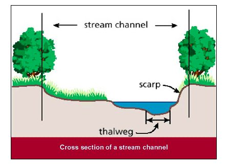
Let’s first understand the meaning of ‘Creek’. Creek is a narrow shelled waterway that appears like a river but its depth is less than a river.
Sir Creek Line is a tidal estuary that is 96km long and located in the uninhabited marshy lands of the Indus River Delta.
Sir Creek also called ‘Ban Ganga’ is named after a British representative. Sir Creek is hard to patrol marshy wetland border area without any fencing or physical border.
Where is Sir Creek Located?
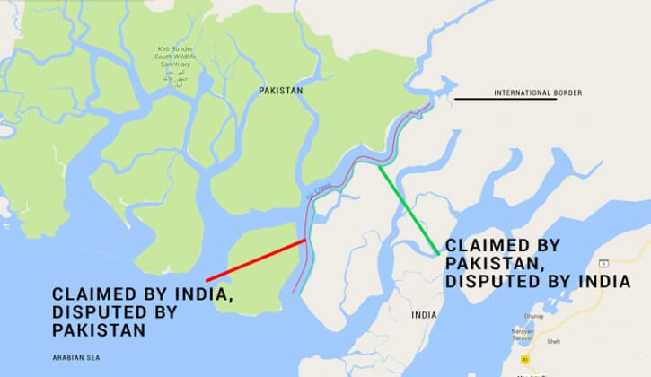
Sir Creek line is located at the Gujarat Border. The Creek roughly separates the Kutch region of Gujarat from the Sindh provision of Pakistan and opens into the Arabian Sea.
Sir Creek line is among six creeks on the Indian side. These are Vian Wari Creek, Pir Sanai Creek, Pabevari Creek, Padala Creek (situated 16 km southeast of Sir Creek), and on the eastern side Kori Creek.
What is Sir Creek Dispute?
The undemarcated maritime boundary between India and Pakistan in the Sir Creek line region is the reason behind the dispute. The bone of contention between India and Pakistan is the interpretation of the boundary between Sindh and Kutch
The History of Sir Creek Line Dispute
In the year 1908, Sir Creek dispute first came to light. This region was the bone of contention between the ruler of Sindh and Rao Maharaj of Kutch. This whole region was a part of the Bombay Presidency under British rule.
In 1911, the Bombay Presidency conducted a survey and in the year 1914 passed a dispute resolution verdict. After the verdict, Sir Creek dispute was shelved. The next 40-50 years were mostly non-significant and peaceful as far as Sir Creek dispute was concerned.
In 1947, Sindh went to Pakistan and Gujarat became part of India. During the 1964 war when the whole India-Pakistan border lit up due to ongoing war, the issue of Sir Creek reemerged. Suddenly Pakistan started claiming that according to the 24th Parallel, half of Rann of Kutch belongs to Pakistan.
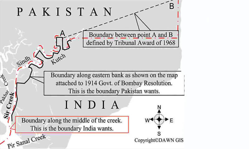
After the 1965 war, the dispute was referred to the International Tribunal for arbitration at the suggestion of British PM Harold Wilson. Both parties agreed to it. The case went to International Tribunal for Arbitration also known as Indo-Pakistani Western Boundary Case Tribunal.
Claims behind Sir Creek Line
On 19 Feb 1968 tribunal delivers its verdict, According to the verdict 90% of the whole Rann of Kutch belongs to India and only 10% of the area belongs to Pakistan. But Pakistan claims that Sir Creek line lies in the Sindh Province so the boundary shifts to the eastern flank of the creek. Pakistan’s claim was based on the Sindh Government resolution of 1914 which was signed by the government of Sindh and Rao Maharaj.
Contradictory claims of Sindh Government Resolution of 1914
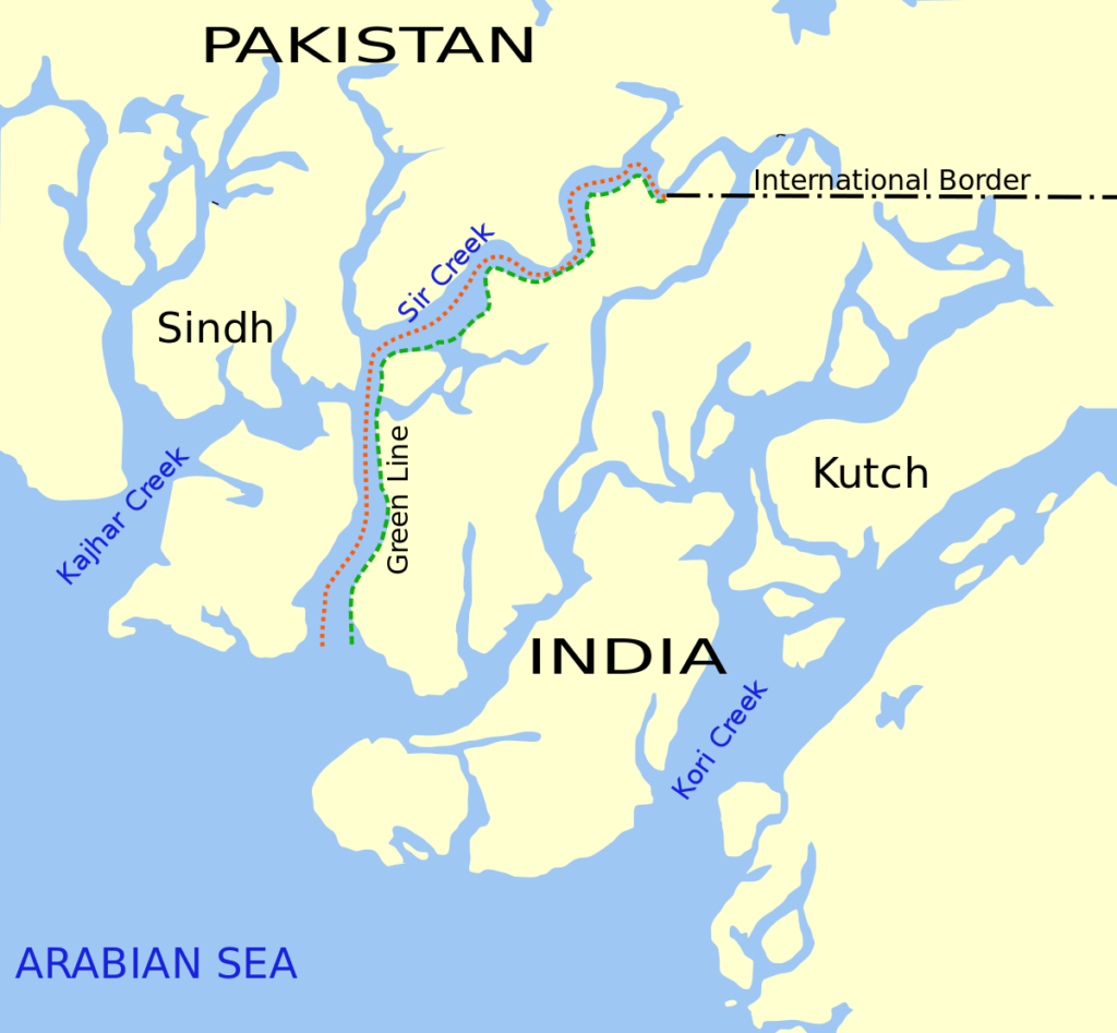
- Para 9: The border of Kutch and Sindh lies to the east of Sir Creek, Pak bases their claims based on this Para.
- Para 10: This part of the resolution says that ‘Sir Creek is navigable most of the year “. India applies the Thalweg Principle which is an international law
Now, let’s understand the meaning of Thalweg Principle.
What is Thalweg Principle?
If a river or water body comes into a border dispute between two countries or political entities then the actual boundary of these two countries will follow the ‘Thalweg’ of this waterway which means the boundary will lie on the center of the principal navigable channel of the water.
And if the river has multiple navigable channels then the strongest current which will be used for downstream travel will be considered
Para 10 confirms that the actual boundary between Sindh and Kutch will lie at the center of Sir Creek.
Being in the parity of International law, the United Nations Convention on the Law of the Sea (UNCLOS) supports India’s position.
Using the Thalweg principle, in 1925 a map was published implementing the mid-channel pillars. Pakistan does not negate the 1925 map. Pakistan claims that this doctrine applies to non-tidal rivers and Sir Creek is a tidal estuary
India claims that Sir Creek is navigable during high tide and the Thalweg principle applies to tidal waters. Over the years Sir Creek has changed its course significantly.
The Economics behind Sir Creek Line
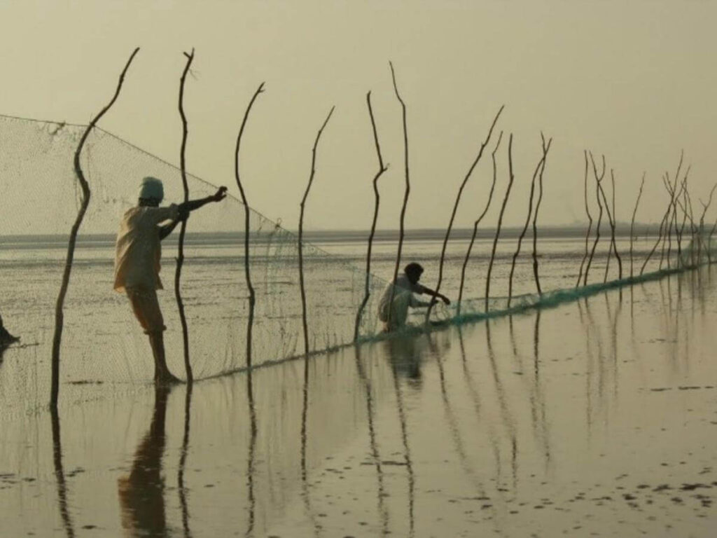
Strategic and Military wise Sir Creek is very important but its importance is in the field of its fishing resources. Sir Creek is one of the largest fishing grounds in Asia. For fishing, many times boats of India and Pakistan enter each other territories. As per the UN for such offenses, the boats should be released after charging a minimum penalty but mostly the fishermen end up in jail on both sides.
According to some reports, there may also be unexplored resources of oil, shale gas, and hydrocarbons under the sea in the region.
The ‘Harami Nala’ in this region is used for illegal drug trafficking and also terrorists used this area to enter India. The 26/11 Mumbai terrorist attack is the best example.
Read More : Who are the Anglo-Indians?
Efforts to Resolve Sir Creek Dispute and Present Situation
Twelve rounds of talks between the two nations from 1997 to 2012 to address the problem but the talks did not conclude in a unanimous decision by the two countries.
During the 2008, 4th round of talks both countries agreed that they will undergo a joint survey and based on that a map will be issued so that this dispute will be resolved but the attempts to resolve the Sir Creek issue by India and Pakistan were halted due to 2008 Mumbai terrorist attacks.
India proposed that the Technical Aspect of the Law of Sea (TALOS) will be used to demarcate maritime boundaries but Pakistan rejected it. According to Pakistan, they want to resolve the Sir Creek Issue and demarcate the boundary after that.
India rejected Pakistan’s proposal to take the issue to International arbitration because in the 1972 Shimla Agreement it was decided to solve the issues between India and Pakistan bilaterally and no third party will be allowed at the table.
At present as per some reports, India is constructing permanent vertical bunkers of concrete to station BSF troops at strategically significant Sir Creek for the first time
2 thoughts on “What is Sir Creek Line? | Why it is still debatable between India and Pakistan?”